


Eus Arboussols

FAUCET
User
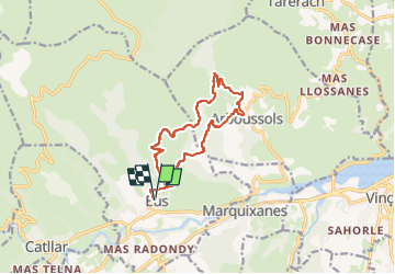

Length
12.8 km

Max alt
714 m

Uphill gradient
441 m
Km-Effort
18.7 km

Min alt
382 m

Downhill gradient
440 m
Boucle
Yes
Creation date :
2025-02-12 12:57:15.104
Updated on :
2025-02-12 12:57:18.034
4h14
Difficulty : Difficult

FREE GPS app for hiking
 SityTrail
IGN / Geographical institutes
SityTrail Plus
The world is yours!
About
Trail Walking of 12.8 km to be discovered at Occitania, Pyrénées-Orientales, Eus. This trail is proposed by FAUCET.
Positioning
Country:
France
Region :
Occitania
Department/Province :
Pyrénées-Orientales
Municipality :
Eus
Location:
Unknown
Start:(Dec)
Start:(UTM)
455498 ; 4721470 (31T) N.
Comments