


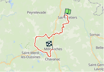
Etape 5 Bis / Saint-Setiers à Milevaches

aucamus
User

Length
21 km

Max alt
917 m

Uphill gradient
471 m
Km-Effort
28 km

Min alt
799 m

Downhill gradient
476 m
Boucle
No
Creation date :
2025-02-12 14:10:00.841
Updated on :
2025-02-12 14:17:51.508
6h18
Difficulty : Very difficult

FREE GPS app for hiking
 SityTrail
IGN / Geographical institutes
SityTrail Plus
The world is yours!
About
Trail Walking of 21 km to be discovered at New Aquitaine, Corrèze, Saint-Setiers. This trail is proposed by aucamus.
Positioning
Country:
France
Region :
New Aquitaine
Department/Province :
Corrèze
Municipality :
Saint-Setiers
Location:
Unknown
Start:(Dec)
Start:(UTM)
431504 ; 5060470 (31T) N.
Comments