


Espinet entre vignes et noyers-13347427

Gpoujade
User
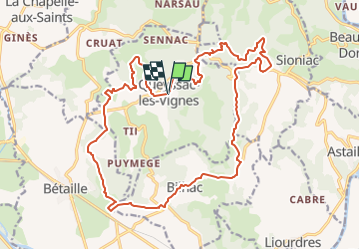

Length
23 km

Max alt
335 m

Uphill gradient
558 m
Km-Effort
30 km

Min alt
126 m

Downhill gradient
551 m
Boucle
Yes
Creation date :
2025-02-12 16:56:52.915
Updated on :
2025-03-15 10:04:34.812
6h54
Difficulty : Very difficult
2h06
Difficulty : Medium

FREE GPS app for hiking
 SityTrail
IGN / Geographical institutes
SityTrail Plus
The world is yours!
About
Trail Walking of 23 km to be discovered at New Aquitaine, Corrèze, Queyssac-les-Vignes. This trail is proposed by Gpoujade.
Positioning
Country:
France
Region :
New Aquitaine
Department/Province :
Corrèze
Municipality :
Queyssac-les-Vignes
Location:
Unknown
Start:(Dec)
Start:(UTM)
402909 ; 4979927 (31T) N.
Comments