


les coches - les bauches

baygonvert
User
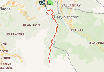

Length
13.7 km

Max alt
1934 m

Uphill gradient
582 m
Km-Effort
21 km

Min alt
1432 m

Downhill gradient
585 m
Boucle
Yes
Creation date :
2025-02-13 09:55:48.093
Updated on :
2025-02-13 18:08:42.633
3h15
Difficulty : Easy

FREE GPS app for hiking
 SityTrail
IGN / Geographical institutes
SityTrail Plus
The world is yours!
About
Trail Trail of 13.7 km to be discovered at Auvergne-Rhône-Alpes, Savoy, La Plagne-Tarentaise. This trail is proposed by baygonvert.
Description
resto friolin. condition : neige 1600m 1350m
Positioning
Country:
France
Region :
Auvergne-Rhône-Alpes
Department/Province :
Savoy
Municipality :
La Plagne-Tarentaise
Location:
Bellentre
Start:(Dec)
Start:(UTM)
323045 ; 5046946 (32T) N.
Comments