


castelnou

Phidel66
User
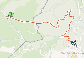

Length
2.4 km

Max alt
337 m

Uphill gradient
42 m
Km-Effort
3.2 km

Min alt
212 m

Downhill gradient
119 m
Boucle
No
Creation date :
2025-02-14 14:06:26.758
Updated on :
2025-02-14 15:04:41.441
57m
Difficulty : Easy

FREE GPS app for hiking
 SityTrail
IGN / Geographical institutes
SityTrail Plus
The world is yours!
About
Trail Walking of 2.4 km to be discovered at Occitania, Pyrénées-Orientales, Camélas. This trail is proposed by Phidel66.
Description
romarins
Positioning
Country:
France
Region :
Occitania
Department/Province :
Pyrénées-Orientales
Municipality :
Camélas
Location:
Unknown
Start:(Dec)
Start:(UTM)
474651 ; 4719236 (31T) N.
Comments