


La Baume (04) - Mandarom

ETMU5496
User

Length
11.7 km

Max alt
1410 m

Uphill gradient
419 m
Km-Effort
17.3 km

Min alt
1044 m

Downhill gradient
416 m
Boucle
Yes
Creation date :
2025-02-16 08:26:51.0
Updated on :
2025-03-03 16:48:54.696
3h55
Difficulty : Medium

FREE GPS app for hiking
 SityTrail
IGN / Geographical institutes
SityTrail Plus
The world is yours!
About
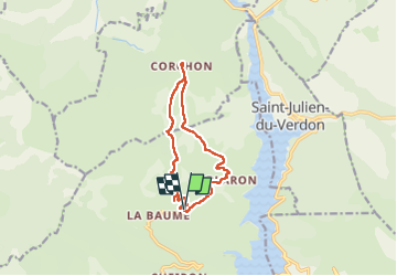
Trail Walking of 11.7 km to be discovered at Provence-Alpes-Côte d'Azur, Alpes-de-Haute-Provence, Castellane. This trail is proposed by ETMU5496.
Description
Courte randonnée dans un secteur dominant le magnifique lac du Castillon et entouré de jolis sommets
La randonnée se termine par une visite du site controversé du Mandarom
Photos
 - Mandarom - Photo 1")
 - Mandarom - Photo 2")
 - Mandarom - Photo 3")
 - Mandarom - Photo 4")
 - Mandarom - Photo 5")
 - Mandarom - Photo 6")
 - Mandarom - Photo 7")
 - Mandarom - Photo 8")
 - Mandarom - Photo 9")
 - Mandarom - Photo 10")
 - Mandarom - Photo 11")
 - Mandarom - Photo 12")
 - Mandarom - Photo 13")
 - Mandarom - Photo 14")
 - Mandarom - Photo 15")
 - Mandarom - Photo 16")
 - Mandarom - Photo 17")
 - Mandarom - Photo 18")
 - Mandarom - Photo 19")
Positioning
Country:
France
Region :
Provence-Alpes-Côte d'Azur
Department/Province :
Alpes-de-Haute-Provence
Municipality :
Castellane
Location:
Unknown
Start:(Dec)
Start:(UTM)
299978 ; 4863021 (32T) N.
Comments