
150225 Poîte de la Cochette

mzonzon05
User
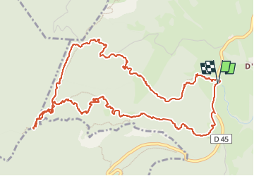

Length
7.3 km

Max alt
1605 m

Uphill gradient
426 m
Km-Effort
13 km

Min alt
1187 m

Downhill gradient
428 m
Boucle
Yes
Creation date :
2025-02-15 10:58:45.065
Updated on :
2025-02-17 12:30:18.51
2h30
Difficulty : Very easy

FREE GPS app for hiking
 SityTrail
IGN / Geographical institutes
SityTrail Plus
The world is yours!
About
Trail Walking of 7.3 km to be discovered at Auvergne-Rhône-Alpes, Savoy, Entremont-le-Vieux. This trail is proposed by mzonzon05.
Description
très jolie balade facile même sans raquettes. Jolie forêt aérée. Et TBeau points de vue sur la Charteeuse au sommet. Merci à Papmounet pour la trace
Photos


Positioning
Country:
France
Region :
Auvergne-Rhône-Alpes
Department/Province :
Savoy
Municipality :
Entremont-le-Vieux
Location:
Unknown
Start:(Dec)
Start:(UTM)
723471 ; 5037934 (31T) N.
Comments