


Lanslebourg > Bessans la Bessanaise

catduv
User
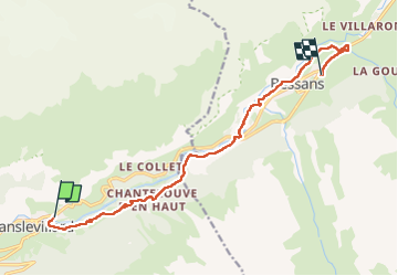

Length
12.1 km

Max alt
1796 m

Uphill gradient
417 m
Km-Effort
16.8 km

Min alt
1470 m

Downhill gradient
159 m
Boucle
No
Creation date :
2025-02-18 08:43:54.786
Updated on :
2025-02-18 14:15:38.976
3h32
Difficulty : Medium

FREE GPS app for hiking
 SityTrail
IGN / Geographical institutes
SityTrail Plus
The world is yours!
About
Trail Snowshoes of 12.1 km to be discovered at Auvergne-Rhône-Alpes, Savoy, Val-Cenis. This trail is proposed by catduv.
Positioning
Country:
France
Region :
Auvergne-Rhône-Alpes
Department/Province :
Savoy
Municipality :
Val-Cenis
Location:
Lanslevillard
Start:(Dec)
Start:(UTM)
336790 ; 5017429 (32T) N.
Comments