


Bourbach

JCLUTT
User
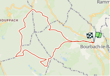

Length
11 km

Max alt
635 m

Uphill gradient
367 m
Km-Effort
15.9 km

Min alt
379 m

Downhill gradient
368 m
Boucle
Yes
Creation date :
2025-02-19 08:24:33.545
Updated on :
2025-02-19 08:27:32.235
3h37
Difficulty : Difficult

FREE GPS app for hiking
 SityTrail
IGN / Geographical institutes
SityTrail Plus
The world is yours!
About
Trail Walking of 11 km to be discovered at Grand Est, Haut-Rhin, Bourbach-le-Bas. This trail is proposed by JCLUTT.
Description
Belle randonnée de reprise ! Longueur suffisante et pas trop de dénivelé !
Positioning
Country:
France
Region :
Grand Est
Department/Province :
Haut-Rhin
Municipality :
Bourbach-le-Bas
Location:
Unknown
Start:(Dec)
Start:(UTM)
354648 ; 5293132 (32T) N.
Comments