


les Verneys - la setaz

laurentnecca
User
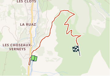

Length
3.7 km

Max alt
2003 m

Uphill gradient
437 m
Km-Effort
8.1 km

Min alt
1559 m

Downhill gradient
5 m
Boucle
No
Creation date :
2025-02-20 10:41:13.497
Updated on :
2025-02-20 12:31:14.838
1h14
Difficulty : Easy

FREE GPS app for hiking
 SityTrail
IGN / Geographical institutes
SityTrail Plus
The world is yours!
About
Trail Touring skiing of 3.7 km to be discovered at Auvergne-Rhône-Alpes, Savoy, Valloire. This trail is proposed by laurentnecca.
Positioning
Country:
France
Region :
Auvergne-Rhône-Alpes
Department/Province :
Savoy
Municipality :
Valloire
Location:
Unknown
Start:(Dec)
Start:(UTM)
297183 ; 5002270 (32T) N.
Comments