


Baudino oppidum 03/25

jacques.seux
User
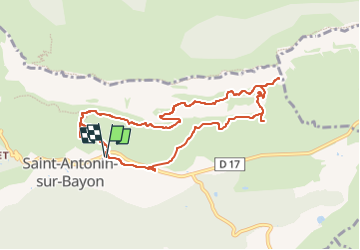

Length
9.5 km

Max alt
825 m

Uphill gradient
561 m
Km-Effort
17 km

Min alt
439 m

Downhill gradient
560 m
Boucle
Yes
Creation date :
2025-02-26 07:42:36.313
Updated on :
2025-02-26 07:44:21.698
3h51
Difficulty : Difficult

FREE GPS app for hiking
 SityTrail
IGN / Geographical institutes
SityTrail Plus
The world is yours!
About
Trail Walking of 9.5 km to be discovered at Provence-Alpes-Côte d'Azur, Bouches-du-Rhône, Saint-Antonin-sur-Bayon. This trail is proposed by jacques.seux.
Positioning
Country:
France
Region :
Provence-Alpes-Côte d'Azur
Department/Province :
Bouches-du-Rhône
Municipality :
Saint-Antonin-sur-Bayon
Location:
Unknown
Start:(Dec)
Start:(UTM)
709235 ; 4821866 (31T) N.
Comments