


Ousse-Assat G4 2025

LouisROGER
User GUIDE
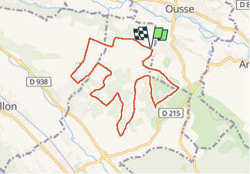

Length
10.3 km

Max alt
324 m

Uphill gradient
212 m
Km-Effort
13.1 km

Min alt
237 m

Downhill gradient
212 m
Boucle
Yes
Creation date :
2025-02-28 09:07:16.201
Updated on :
2025-02-28 13:38:11.47
4h30
Difficulty : Difficult

FREE GPS app for hiking
 SityTrail
IGN / Geographical institutes
SityTrail Plus
The world is yours!
About
Trail Walking of 10.3 km to be discovered at New Aquitaine, Pyrénées-Atlantiques, Assat. This trail is proposed by LouisROGER.
Positioning
Country:
France
Region :
New Aquitaine
Department/Province :
Pyrénées-Atlantiques
Municipality :
Assat
Location:
Unknown
Start:(Dec)
Start:(UTM)
721091 ; 4795047 (30T) N.
Comments