


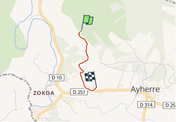
Ayherre 2025

jcm17
User

Length
1.2 km

Max alt
135 m

Uphill gradient
11 m
Km-Effort
1.6 km

Min alt
54 m

Downhill gradient
75 m
Boucle
No
Creation date :
2025-03-01 11:14:35.084
Updated on :
2025-03-01 11:41:02.425
26m
Difficulty : Easy

FREE GPS app for hiking
 SityTrail
IGN / Geographical institutes
SityTrail Plus
The world is yours!
About
Trail Walking of 1.2 km to be discovered at New Aquitaine, Pyrénées-Atlantiques, Ayherre. This trail is proposed by jcm17.
Positioning
Country:
France
Region :
New Aquitaine
Department/Province :
Pyrénées-Atlantiques
Municipality :
Ayherre
Location:
Unknown
Start:(Dec)
Start:(UTM)
640496 ; 4806675 (30T) N.
Comments