


La Rhune

jfcontour
User
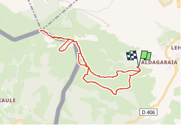

Length
10.5 km

Max alt
899 m

Uphill gradient
783 m
Km-Effort
21 km

Min alt
223 m

Downhill gradient
783 m
Boucle
Yes
Creation date :
2025-03-02 10:16:28.823
Updated on :
2025-03-02 14:29:14.544
4h12
Difficulty : Easy

FREE GPS app for hiking
 SityTrail
IGN / Geographical institutes
SityTrail Plus
The world is yours!
About
Trail Walking of 10.5 km to be discovered at New Aquitaine, Pyrénées-Atlantiques, Sare. This trail is proposed by jfcontour.
Description
la Rhune depuis Sare
Positioning
Country:
France
Region :
New Aquitaine
Department/Province :
Pyrénées-Atlantiques
Municipality :
Sare
Location:
Unknown
Start:(Dec)
Start:(UTM)
613385 ; 4795082 (30T) N.
Comments