


Trail Planner Map

daniel_2w
User
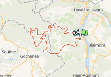

Length
17 km

Max alt
257 m

Uphill gradient
383 m
Km-Effort
22 km

Min alt
99 m

Downhill gradient
376 m
Boucle
Yes
Creation date :
2025-03-02 20:12:44.614
Updated on :
2025-03-02 20:14:08.12
0m
Difficulty : Easy

FREE GPS app for hiking
 SityTrail
IGN / Geographical institutes
SityTrail Plus
The world is yours!
About
Trail Nordic walking of 17 km to be discovered at Wallonia, Namur, Hastière. This trail is proposed by daniel_2w.
Positioning
Country:
Belgium
Region :
Wallonia
Department/Province :
Namur
Municipality :
Hastière
Location:
Unknown
Start:(Dec)
Start:(UTM)
629685 ; 5561992 (31U) N.
Comments