


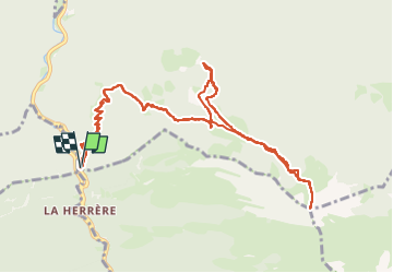
Pic Estibette et monbula

chasle
User

Length
13.4 km

Max alt
1813 m

Uphill gradient
1519 m
Km-Effort
34 km

Min alt
461 m

Downhill gradient
1516 m
Boucle
Yes
Creation date :
2025-03-04 06:37:06.336
Updated on :
2025-03-05 17:29:12.691
7h38
Difficulty : Difficult

FREE GPS app for hiking
 SityTrail
IGN / Geographical institutes
SityTrail Plus
The world is yours!
About
Trail Walking of 13.4 km to be discovered at New Aquitaine, Pyrénées-Atlantiques, Asson. This trail is proposed by chasle.
Positioning
Country:
France
Region :
New Aquitaine
Department/Province :
Pyrénées-Atlantiques
Municipality :
Asson
Location:
Unknown
Start:(Dec)
Start:(UTM)
723212 ; 4768747 (30T) N.
Comments