


Castellane p'tit tour

taguette
User
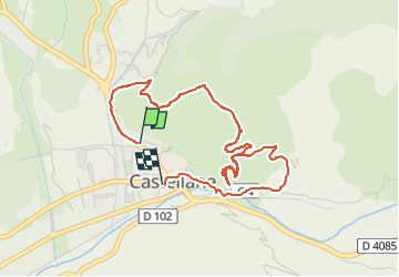

Length
4.6 km

Max alt
888 m

Uphill gradient
274 m
Km-Effort
8.3 km

Min alt
721 m

Downhill gradient
281 m
Boucle
No
Creation date :
2025-03-05 09:23:49.114
Updated on :
2025-03-05 11:23:39.636
1h53
Difficulty : Medium

FREE GPS app for hiking
 SityTrail
IGN / Geographical institutes
SityTrail Plus
The world is yours!
About
Trail Walking of 4.6 km to be discovered at Provence-Alpes-Côte d'Azur, Alpes-de-Haute-Provence, Castellane. This trail is proposed by taguette.
Positioning
Country:
France
Region :
Provence-Alpes-Côte d'Azur
Department/Province :
Alpes-de-Haute-Provence
Municipality :
Castellane
Location:
Unknown
Start:(Dec)
Start:(UTM)
299908 ; 4858040 (32T) N.
Comments