


CHAUTAGNE: VIONS - PONT DE LA LOI - BORDS DU RHONE

djeepee74
User
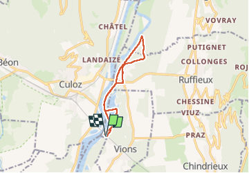

Length
10.3 km

Max alt
296 m

Uphill gradient
102 m
Km-Effort
11.7 km

Min alt
234 m

Downhill gradient
102 m
Boucle
Yes
Creation date :
2025-03-06 12:54:16.159
Updated on :
2025-03-31 18:36:31.007
2h38
Difficulty : Easy

FREE GPS app for hiking
 SityTrail
IGN / Geographical institutes
SityTrail Plus
The world is yours!
About
Trail Walking of 10.3 km to be discovered at Auvergne-Rhône-Alpes, Savoy, Vions. This trail is proposed by djeepee74.
Description
BOUCLE... live du 20250306
Positioning
Country:
France
Region :
Auvergne-Rhône-Alpes
Department/Province :
Savoy
Municipality :
Vions
Location:
Unknown
Start:(Dec)
Start:(UTM)
717371 ; 5078922 (31T) N.
Comments