


villerach

Magalimaria11
User
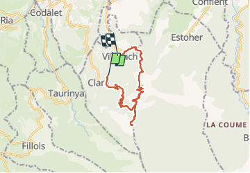

Length
11.7 km

Max alt
1389 m

Uphill gradient
894 m
Km-Effort
24 km

Min alt
460 m

Downhill gradient
1019 m
Boucle
No
Creation date :
2025-03-06 08:14:22.4
Updated on :
2025-03-06 15:33:10.928
4h23
Difficulty : Very difficult

FREE GPS app for hiking
 SityTrail
IGN / Geographical institutes
SityTrail Plus
The world is yours!
About
Trail Walking of 11.7 km to be discovered at Occitania, Pyrénées-Orientales, Clara-Villerach. This trail is proposed by Magalimaria11.
Positioning
Country:
France
Region :
Occitania
Department/Province :
Pyrénées-Orientales
Municipality :
Clara-Villerach
Location:
Unknown
Start:(Dec)
Start:(UTM)
454681 ; 4715141 (31T) N.
Comments