


montchavin-vanoise express-les coches-montchavin

lamortgregory
User
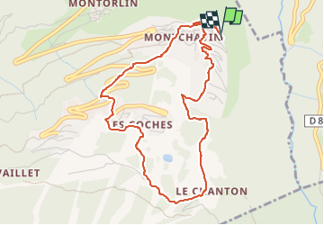

Length
5.2 km

Max alt
1554 m

Uphill gradient
369 m
Km-Effort
10.1 km

Min alt
1174 m

Downhill gradient
368 m
Boucle
Yes
Creation date :
2025-03-06 14:55:07.32
Updated on :
2025-03-06 16:22:52.693
1h27
Difficulty : Medium

FREE GPS app for hiking
 SityTrail
IGN / Geographical institutes
SityTrail Plus
The world is yours!
About
Trail Walking of 5.2 km to be discovered at Auvergne-Rhône-Alpes, Savoy, La Plagne-Tarentaise. This trail is proposed by lamortgregory.
Positioning
Country:
France
Region :
Auvergne-Rhône-Alpes
Department/Province :
Savoy
Municipality :
La Plagne-Tarentaise
Location:
Bellentre
Start:(Dec)
Start:(UTM)
323638 ; 5047645 (32T) N.
Comments