


VTT du 09-03-25

dudu79
User

Length
41 km

Max alt
225 m

Uphill gradient
403 m
Km-Effort
46 km

Min alt
158 m

Downhill gradient
397 m
Boucle
Yes
Creation date :
2025-03-09 07:05:36.189
Updated on :
2025-03-09 07:06:08.449
3h13
Difficulty : Very difficult

FREE GPS app for hiking
 SityTrail
IGN / Geographical institutes
SityTrail Plus
The world is yours!
About
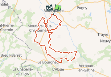
Trail Mountain bike of 41 km to be discovered at New Aquitaine, Deux-Sèvres, Moncoutant-sur-Sèvre. This trail is proposed by dudu79.
Positioning
Country:
France
Region :
New Aquitaine
Department/Province :
Deux-Sèvres
Municipality :
Moncoutant-sur-Sèvre
Location:
Moncoutant
Start:(Dec)
Start:(UTM)
684418 ; 5176492 (30T) N.
Comments