


sortie moncoutantaise 2025

dudu79
User
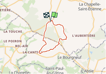

Length
9.7 km

Max alt
237 m

Uphill gradient
155 m
Km-Effort
11.8 km

Min alt
160 m

Downhill gradient
156 m
Boucle
Yes
Creation date :
2025-03-12 08:05:15.673
Updated on :
2025-03-12 08:06:22.855
2h40
Difficulty : Medium

FREE GPS app for hiking
 SityTrail
IGN / Geographical institutes
SityTrail Plus
The world is yours!
About
Trail Walking of 9.7 km to be discovered at New Aquitaine, Deux-Sèvres, Moncoutant-sur-Sèvre. This trail is proposed by dudu79.
Positioning
Country:
France
Region :
New Aquitaine
Department/Province :
Deux-Sèvres
Municipality :
Moncoutant-sur-Sèvre
Location:
Moutiers-sous-Chantemerle
Start:(Dec)
Start:(UTM)
681979 ; 5171467 (30T) N.
Comments