


sortie VTT du Club

dudu79
User
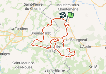

Length
38 km

Max alt
233 m

Uphill gradient
678 m
Km-Effort
47 km

Min alt
116 m

Downhill gradient
678 m
Boucle
Yes
Creation date :
2025-03-14 07:11:03.262
Updated on :
2025-03-14 07:50:43.77
3h14
Difficulty : Very difficult

FREE GPS app for hiking
 SityTrail
IGN / Geographical institutes
SityTrail Plus
The world is yours!
About
Trail Mountain bike of 38 km to be discovered at New Aquitaine, Deux-Sèvres, Moncoutant-sur-Sèvre. This trail is proposed by dudu79.
Positioning
Country:
France
Region :
New Aquitaine
Department/Province :
Deux-Sèvres
Municipality :
Moncoutant-sur-Sèvre
Location:
Moutiers-sous-Chantemerle
Start:(Dec)
Start:(UTM)
681975 ; 5171461 (30T) N.
Comments