


rando nadîne saint paul

PhilMarie
User
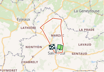

Length
9 km

Max alt
404 m

Uphill gradient
177 m
Km-Effort
11.4 km

Min alt
304 m

Downhill gradient
177 m
Boucle
Yes
Creation date :
2025-03-16 12:32:11.685
Updated on :
2025-03-16 16:11:35.667
3h38
Difficulty : Medium

FREE GPS app for hiking
 SityTrail
IGN / Geographical institutes
SityTrail Plus
The world is yours!
About
Trail Walking of 9 km to be discovered at New Aquitaine, Haute-Vienne, Saint-Paul. This trail is proposed by PhilMarie.
Description
marche
Positioning
Country:
France
Region :
New Aquitaine
Department/Province :
Haute-Vienne
Municipality :
Saint-Paul
Location:
Unknown
Start:(Dec)
Start:(UTM)
378064 ; 5067393 (31T) N.
Comments