


coll de Fins Escarro Aytua la tranchée

FAUCET
User
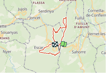

Length
13.5 km

Max alt
1045 m

Uphill gradient
538 m
Km-Effort
21 km

Min alt
717 m

Downhill gradient
541 m
Boucle
Yes
Creation date :
2025-03-19 16:45:53.692
Updated on :
2025-03-19 16:45:56.334
4h42
Difficulty : Very difficult

FREE GPS app for hiking
 SityTrail
IGN / Geographical institutes
SityTrail Plus
The world is yours!
About
Trail Walking of 13.5 km to be discovered at Occitania, Pyrénées-Orientales, Escaro. This trail is proposed by FAUCET.
Positioning
Country:
France
Region :
Occitania
Department/Province :
Pyrénées-Orientales
Municipality :
Escaro
Location:
Unknown
Start:(Dec)
Start:(UTM)
445664 ; 4709250 (31T) N.
Comments