


schauenberg

jcschubnel
User
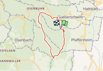

Length
12.9 km

Max alt
588 m

Uphill gradient
347 m
Km-Effort
17.6 km

Min alt
397 m

Downhill gradient
353 m
Boucle
Yes
Creation date :
2024-11-11 10:10:16.699
Updated on :
2025-03-20 14:51:12.7
4h21
Difficulty : Difficult

FREE GPS app for hiking
 SityTrail
IGN / Geographical institutes
SityTrail Plus
The world is yours!
About
Trail Walking of 12.9 km to be discovered at Grand Est, Haut-Rhin, Pfaffenheim. This trail is proposed by jcschubnel.
Positioning
Country:
France
Region :
Grand Est
Department/Province :
Haut-Rhin
Municipality :
Pfaffenheim
Location:
Unknown
Start:(Dec)
Start:(UTM)
370515 ; 5317091 (32T) N.
Comments