


CHAUTAGNE: MOTZ

djeepee74
User
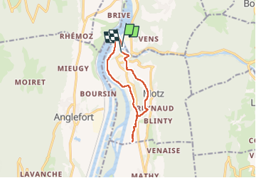

Length
10 km

Max alt
407 m

Uphill gradient
255 m
Km-Effort
13.4 km

Min alt
243 m

Downhill gradient
247 m
Boucle
No
Creation date :
2025-03-20 12:15:10.748
Updated on :
2025-03-31 18:30:19.785
3h03
Difficulty : Easy

FREE GPS app for hiking
 SityTrail
IGN / Geographical institutes
SityTrail Plus
The world is yours!
About
Trail Walking of 10 km to be discovered at Auvergne-Rhône-Alpes, Savoy, Motz. This trail is proposed by djeepee74.
Description
BOUCLE... live du 20250320
Positioning
Country:
France
Region :
Auvergne-Rhône-Alpes
Department/Province :
Savoy
Municipality :
Motz
Location:
Unknown
Start:(Dec)
Start:(UTM)
719540 ; 5090773 (31T) N.
Comments