


glacier

mthomas30
User
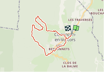

Length
7.9 km

Max alt
1313 m

Uphill gradient
246 m
Km-Effort
11.1 km

Min alt
1096 m

Downhill gradient
246 m
Boucle
Yes
Creation date :
2025-03-22 08:31:28.263
Updated on :
2025-03-22 10:55:34.927
2h01
Difficulty : Easy

FREE GPS app for hiking
 SityTrail
IGN / Geographical institutes
SityTrail Plus
The world is yours!
About
Trail Walking of 7.9 km to be discovered at Auvergne-Rhône-Alpes, Isère, Corrençon-en-Vercors. This trail is proposed by mthomas30.
Positioning
Country:
France
Region :
Auvergne-Rhône-Alpes
Department/Province :
Isère
Municipality :
Corrençon-en-Vercors
Location:
Unknown
Start:(Dec)
Start:(UTM)
699407 ; 4989728 (31T) N.
Comments