


tours

mthomas30
User
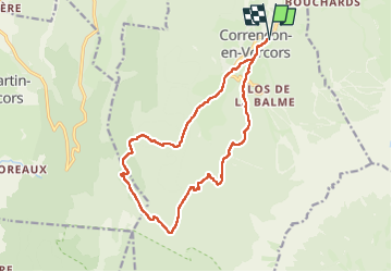

Length
15.9 km

Max alt
1456 m

Uphill gradient
532 m
Km-Effort
23 km

Min alt
1096 m

Downhill gradient
533 m
Boucle
Yes
Creation date :
2025-03-22 13:36:17.891
Updated on :
2025-03-25 16:59:39.256
3h42
Difficulty : Difficult

FREE GPS app for hiking
 SityTrail
IGN / Geographical institutes
SityTrail Plus
The world is yours!
About
Trail Walking of 15.9 km to be discovered at Auvergne-Rhône-Alpes, Isère, Corrençon-en-Vercors. This trail is proposed by mthomas30.
Positioning
Country:
France
Region :
Auvergne-Rhône-Alpes
Department/Province :
Isère
Municipality :
Corrençon-en-Vercors
Location:
Unknown
Start:(Dec)
Start:(UTM)
699401 ; 4989716 (31T) N.
Comments