


Thann-becherkopf

JCLUTT
User
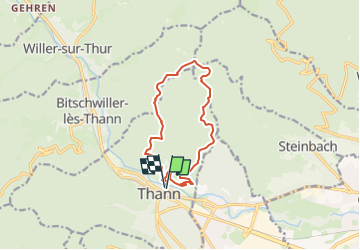

Length
12.6 km

Max alt
867 m

Uphill gradient
594 m
Km-Effort
20 km

Min alt
333 m

Downhill gradient
593 m
Boucle
Yes
Creation date :
2025-03-26 10:02:02.047
Updated on :
2025-03-26 10:15:13.139
4h39
Difficulty : Very difficult

FREE GPS app for hiking
 SityTrail
IGN / Geographical institutes
SityTrail Plus
The world is yours!
About
Trail Walking of 12.6 km to be discovered at Grand Est, Haut-Rhin, Thann. This trail is proposed by JCLUTT.
Description
Belle randonnée de difficulté soutenue !
Positioning
Country:
France
Region :
Grand Est
Department/Province :
Haut-Rhin
Municipality :
Thann
Location:
Unknown
Start:(Dec)
Start:(UTM)
358116 ; 5297066 (32T) N.
Comments