


St Christophe des bardes

Gbreuilh
User
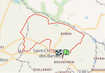

Length
10.1 km

Max alt
90 m

Uphill gradient
135 m
Km-Effort
11.9 km

Min alt
26 m

Downhill gradient
135 m
Boucle
Yes
Creation date :
2025-03-26 08:30:56.782
Updated on :
2025-03-26 11:06:07.108
2h34
Difficulty : Medium

FREE GPS app for hiking
 SityTrail
IGN / Geographical institutes
SityTrail Plus
The world is yours!
About
Trail Walking of 10.1 km to be discovered at New Aquitaine, Gironde, Saint-Christophe-des-Bardes. This trail is proposed by Gbreuilh.
Positioning
Country:
France
Region :
New Aquitaine
Department/Province :
Gironde
Municipality :
Saint-Christophe-des-Bardes
Location:
Unknown
Start:(Dec)
Start:(UTM)
727703 ; 4975176 (30T) N.
Comments