


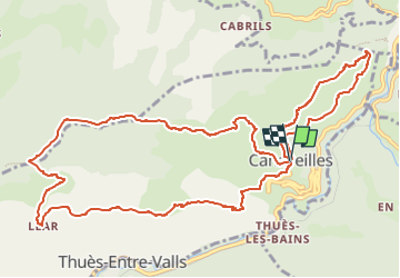
canaveilles à llar

FAUCET
User

Length
14.6 km

Max alt
1623 m

Uphill gradient
858 m
Km-Effort
26 km

Min alt
818 m

Downhill gradient
868 m
Boucle
Yes
Creation date :
2025-03-26 13:02:18.8
Updated on :
2025-03-26 13:02:21.036
5h55
Difficulty : Very difficult

FREE GPS app for hiking
 SityTrail
IGN / Geographical institutes
SityTrail Plus
The world is yours!
About
Trail Walking of 14.6 km to be discovered at Occitania, Pyrénées-Orientales, Canaveilles. This trail is proposed by FAUCET.
Positioning
Country:
France
Region :
Occitania
Department/Province :
Pyrénées-Orientales
Municipality :
Canaveilles
Location:
Unknown
Start:(Dec)
Start:(UTM)
438390 ; 4709663 (31T) N.
Comments