


roderen- copains- Thierry

chantalwaltzer
User
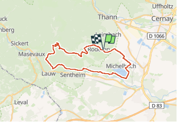

Length
28 km

Max alt
765 m

Uphill gradient
747 m
Km-Effort
38 km

Min alt
307 m

Downhill gradient
747 m
Boucle
Yes
Creation date :
2025-03-30 06:59:32.0
Updated on :
2025-03-30 16:01:21.877
8h58
Difficulty : Very difficult

FREE GPS app for hiking
 SityTrail
IGN / Geographical institutes
SityTrail Plus
The world is yours!
About
Trail Walking of 28 km to be discovered at Grand Est, Haut-Rhin, Roderen. This trail is proposed by chantalwaltzer.
Description
Bien
Positioning
Country:
France
Region :
Grand Est
Department/Province :
Haut-Rhin
Municipality :
Roderen
Location:
Unknown
Start:(Dec)
Start:(UTM)
357385 ; 5293438 (32T) N.
Comments