


TRK000

JCLUTT
User
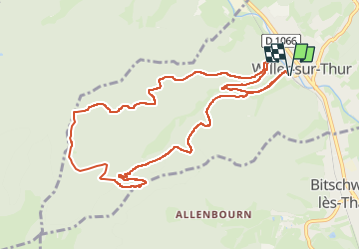

Length
11.1 km

Max alt
815 m

Uphill gradient
488 m
Km-Effort
17.6 km

Min alt
366 m

Downhill gradient
487 m
Boucle
Yes
Creation date :
2025-04-02 17:09:45.766
Updated on :
2025-04-02 17:12:54.791
3h59
Difficulty : Difficult

FREE GPS app for hiking
 SityTrail
IGN / Geographical institutes
SityTrail Plus
The world is yours!
About
Trail Walking of 11.1 km to be discovered at Grand Est, Haut-Rhin, Willer-sur-Thur. This trail is proposed by JCLUTT.
Description
Belle randonnée de difficulté moyenne !
Positioning
Country:
France
Region :
Grand Est
Department/Province :
Haut-Rhin
Municipality :
Willer-sur-Thur
Location:
Unknown
Start:(Dec)
Start:(UTM)
355500 ; 5300647 (32T) N.
Comments