


les ventrons

gerard70
User
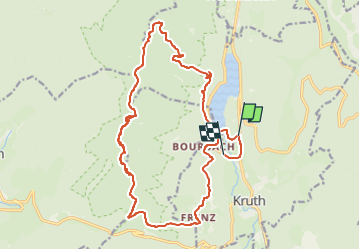

Length
20 km

Max alt
1202 m

Uphill gradient
927 m
Km-Effort
33 km

Min alt
500 m

Downhill gradient
952 m
Boucle
No
Creation date :
2025-04-07 15:22:06.742
Updated on :
2025-06-22 14:59:33.07
7h27
Difficulty : Difficult

FREE GPS app for hiking
 SityTrail
IGN / Geographical institutes
SityTrail Plus
The world is yours!
About
Trail On foot of 20 km to be discovered at Grand Est, Haut-Rhin, Kruth. This trail is proposed by gerard70.
Positioning
Country:
France
Region :
Grand Est
Department/Province :
Haut-Rhin
Municipality :
Kruth
Location:
Unknown
Start:(Dec)
Start:(UTM)
347733 ; 5312260 (32T) N.
Comments