


Lispac - Oltingue

Alain28/01
User
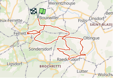

Length
21 km

Max alt
639 m

Uphill gradient
627 m
Km-Effort
30 km

Min alt
410 m

Downhill gradient
632 m
Boucle
Yes
Creation date :
2025-04-07 17:42:27.441
Updated on :
2025-04-07 17:43:37.46
6h47
Difficulty : Difficult

FREE GPS app for hiking
 SityTrail
IGN / Geographical institutes
SityTrail Plus
The world is yours!
About
Trail Walking of 21 km to be discovered at Grand Est, Haut-Rhin, Bouxwiller. This trail is proposed by Alain28/01.
Positioning
Country:
France
Region :
Grand Est
Department/Province :
Haut-Rhin
Municipality :
Bouxwiller
Location:
Unknown
Start:(Dec)
Start:(UTM)
374463 ; 5262683 (32T) N.
Comments