


lafage

chanac les mines
User
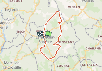

Length
12.8 km

Max alt
681 m

Uphill gradient
238 m
Km-Effort
16 km

Min alt
552 m

Downhill gradient
239 m
Boucle
Yes
Creation date :
2025-04-08 11:57:23.237
Updated on :
2025-04-08 15:25:48.094
3h27
Difficulty : Difficult

FREE GPS app for hiking
 SityTrail
IGN / Geographical institutes
SityTrail Plus
The world is yours!
About
Trail Walking of 12.8 km to be discovered at New Aquitaine, Corrèze, Lafage-sur-Sombre. This trail is proposed by chanac les mines.
Positioning
Country:
France
Region :
New Aquitaine
Department/Province :
Corrèze
Municipality :
Lafage-sur-Sombre
Location:
Unknown
Start:(Dec)
Start:(UTM)
427212 ; 5016081 (31T) N.
Comments