


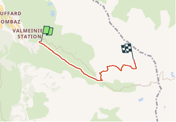
Valmeinier -la Sandonniere

laurentnecca
User

Length
4.3 km

Max alt
2680 m

Uphill gradient
808 m
Km-Effort
12.4 km

Min alt
1864 m

Downhill gradient
4 m
Boucle
No
Creation date :
2025-04-08 08:34:50.082
Updated on :
2025-04-08 15:49:20.546
1h49
Difficulty : Medium

FREE GPS app for hiking
 SityTrail
IGN / Geographical institutes
SityTrail Plus
The world is yours!
About
Trail Touring skiing of 4.3 km to be discovered at Auvergne-Rhône-Alpes, Savoy, Valmeinier. This trail is proposed by laurentnecca.
Positioning
Country:
France
Region :
Auvergne-Rhône-Alpes
Department/Province :
Savoy
Municipality :
Valmeinier
Location:
Unknown
Start:(Dec)
Start:(UTM)
303503 ; 5005256 (32T) N.
Comments