


Le Collet du Linge

Claudele
User
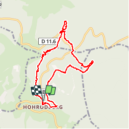

Length
10 km

Max alt
1048 m

Uphill gradient
290 m
Km-Effort
13.9 km

Min alt
805 m

Downhill gradient
296 m
Boucle
Yes
Creation date :
2015-07-08 00:00:00.0
Updated on :
2015-07-08 00:00:00.0
5h16
Difficulty : Medium

FREE GPS app for hiking
 SityTrail
IGN / Geographical institutes
SityTrail Plus
The world is yours!
About
Trail Walking of 10 km to be discovered at Grand Est, Haut-Rhin, Hohrod. This trail is proposed by Claudele.
Positioning
Country:
France
Region :
Grand Est
Department/Province :
Haut-Rhin
Municipality :
Hohrod
Location:
Unknown
Start:(Dec)
Start:(UTM)
360957 ; 5325479 (32U) N.
Comments