


ruine Hugstein

hofsteti68r
User
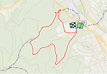

Length
4.3 km

Max alt
484 m

Uphill gradient
155 m
Km-Effort
6.3 km

Min alt
330 m

Downhill gradient
152 m
Boucle
Yes
Creation date :
2025-04-12 08:41:51.296
Updated on :
2025-04-12 10:29:40.786
1h47
Difficulty : Very easy

FREE GPS app for hiking
 SityTrail
IGN / Geographical institutes
SityTrail Plus
The world is yours!
About
Trail Walking of 4.3 km to be discovered at Grand Est, Haut-Rhin, Guebwiller. This trail is proposed by hofsteti68r .
Positioning
Country:
France
Region :
Grand Est
Department/Province :
Haut-Rhin
Municipality :
Guebwiller
Location:
Unknown
Start:(Dec)
Start:(UTM)
365257 ; 5308603 (32T) N.
Comments