


podenbsac

Nordic33
User GUIDE
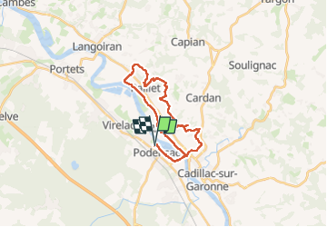

Length
26 km

Max alt
94 m

Uphill gradient
379 m
Km-Effort
31 km

Min alt
1 m

Downhill gradient
380 m
Boucle
Yes
Creation date :
2025-04-13 06:43:35.648
Updated on :
2025-04-26 10:48:16.711
4h41
Difficulty : Very difficult

FREE GPS app for hiking
 SityTrail
IGN / Geographical institutes
SityTrail Plus
The world is yours!
About
Trail Walking of 26 km to be discovered at New Aquitaine, Gironde, Podensac. This trail is proposed by Nordic33.
Positioning
Country:
France
Region :
New Aquitaine
Department/Province :
Gironde
Municipality :
Podensac
Location:
Unknown
Start:(Dec)
Start:(UTM)
709538 ; 4947996 (30T) N.
Comments