


Urbanya

FAUCET
User

Length
38 km

Max alt
1543 m

Uphill gradient
1590 m
Km-Effort
60 km

Min alt
339 m

Downhill gradient
1590 m
Boucle
Yes
Creation date :
2025-04-15 12:40:25.419
Updated on :
2025-04-15 12:40:27.221
4h07
Difficulty : Very difficult

FREE GPS app for hiking
 SityTrail
IGN / Geographical institutes
SityTrail Plus
The world is yours!
About
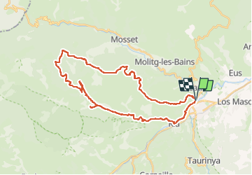
Trail Mountain bike of 38 km to be discovered at Occitania, Pyrénées-Orientales, Prades. This trail is proposed by FAUCET.
Positioning
Country:
France
Region :
Occitania
Department/Province :
Pyrénées-Orientales
Municipality :
Prades
Location:
Unknown
Start:(Dec)
Start:(UTM)
452337 ; 4719311 (31T) N.
Comments