


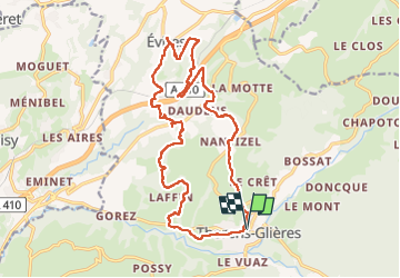
Boucle de Thorens-Glières à Evires

Chabard
User

Length
20 km

Max alt
904 m

Uphill gradient
671 m
Km-Effort
29 km

Min alt
613 m

Downhill gradient
671 m
Boucle
Yes
Creation date :
2025-04-15 06:46:24.0
Updated on :
2025-04-15 17:54:07.689
7h25
Difficulty : Medium

FREE GPS app for hiking
 SityTrail
IGN / Geographical institutes
SityTrail Plus
The world is yours!
About
Trail Walking of 20 km to be discovered at Auvergne-Rhône-Alpes, Upper Savoy, Fillière. This trail is proposed by Chabard.
Description
Boucle de Thorens-Glières à Evires avec un peu de hors piste !
Positioning
Country:
France
Region :
Auvergne-Rhône-Alpes
Department/Province :
Upper Savoy
Municipality :
Fillière
Location:
Unknown
Start:(Dec)
Start:(UTM)
286945 ; 5097431 (32T) N.
Comments