


Parcours n°56

dudu79
User
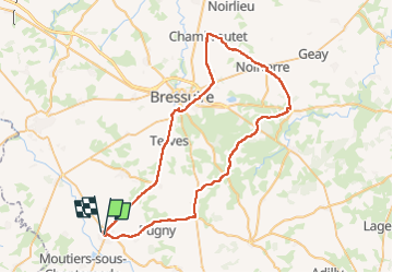

Length
63 km

Max alt
232 m

Uphill gradient
618 m
Km-Effort
72 km

Min alt
136 m

Downhill gradient
626 m
Boucle
No
Creation date :
2025-04-16 13:20:56.036
Updated on :
2025-04-16 13:23:07.451
4h20
Difficulty : Very difficult

FREE GPS app for hiking
 SityTrail
IGN / Geographical institutes
SityTrail Plus
The world is yours!
About
Trail Road bike of 63 km to be discovered at New Aquitaine, Deux-Sèvres, Moncoutant-sur-Sèvre. This trail is proposed by dudu79.
Positioning
Country:
France
Region :
New Aquitaine
Department/Province :
Deux-Sèvres
Municipality :
Moncoutant-sur-Sèvre
Location:
Unknown
Start:(Dec)
Start:(UTM)
684145 ; 5177277 (30T) N.
Comments