


GR5 J52

Airelle
User
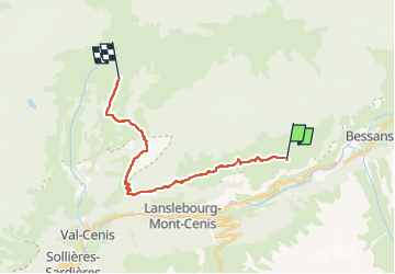

Length
18.5 km

Max alt
2478 m

Uphill gradient
855 m
Km-Effort
30 km

Min alt
1929 m

Downhill gradient
739 m
Boucle
No
Creation date :
2025-04-17 16:08:00.47
Updated on :
2025-04-17 16:08:40.794
6h42
Difficulty : Very difficult

FREE GPS app for hiking
 SityTrail
IGN / Geographical institutes
SityTrail Plus
The world is yours!
About
Trail Walking of 18.5 km to be discovered at Auvergne-Rhône-Alpes, Savoy, Val-Cenis. This trail is proposed by Airelle.
Positioning
Country:
France
Region :
Auvergne-Rhône-Alpes
Department/Province :
Savoy
Municipality :
Val-Cenis
Location:
Lanslevillard
Start:(Dec)
Start:(UTM)
338661 ; 5019452 (32T) N.
Comments