


2025 descente de la vallée de thann

staubalex
User
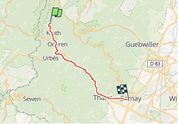

Length
30 km

Max alt
565 m

Uphill gradient
298 m
Km-Effort
35 km

Min alt
296 m

Downhill gradient
549 m
Boucle
No
Creation date :
2025-04-20 09:31:39.482
Updated on :
2025-04-20 09:32:57.553
2h30
Difficulty : Medium

FREE GPS app for hiking
 SityTrail
IGN / Geographical institutes
SityTrail Plus
The world is yours!
About
Trail Other activity of 30 km to be discovered at Grand Est, Haut-Rhin, Kruth. This trail is proposed by staubalex.
Positioning
Country:
France
Region :
Grand Est
Department/Province :
Haut-Rhin
Municipality :
Kruth
Location:
Unknown
Start:(Dec)
Start:(UTM)
347422 ; 5312452 (32T) N.
Comments