


Fumel les 47 du 47

leglisemichel
User
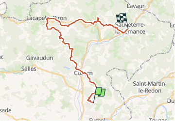

Length
30 km

Max alt
252 m

Uphill gradient
721 m
Km-Effort
39 km

Min alt
94 m

Downhill gradient
715 m
Boucle
No
Creation date :
2025-04-27 06:41:33.0
Updated on :
2025-04-27 13:31:40.464
6h48
Difficulty : Very difficult

FREE GPS app for hiking
 SityTrail
IGN / Geographical institutes
SityTrail Plus
The world is yours!
About
Trail Walking of 30 km to be discovered at New Aquitaine, Lot-et-Garonne, Fumel. This trail is proposed by leglisemichel.
Positioning
Country:
France
Region :
New Aquitaine
Department/Province :
Lot-et-Garonne
Municipality :
Fumel
Location:
Unknown
Start:(Dec)
Start:(UTM)
338103 ; 4931057 (31T) N.
Comments