


2025 05 sortie muni Rocher Turren / Eguisheim

staubalex
User
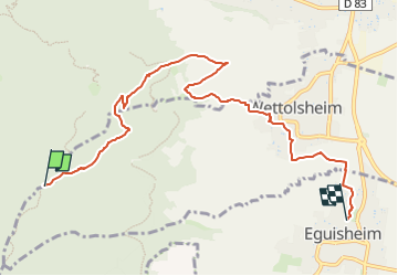

Length
7.4 km

Max alt
631 m

Uphill gradient
25 m
Km-Effort
9.2 km

Min alt
196 m

Downhill gradient
456 m
Boucle
No
Creation date :
2025-05-02 16:42:05.761
Updated on :
2025-05-02 16:43:30.45
2h00
Difficulty : Medium

FREE GPS app for hiking
 SityTrail
IGN / Geographical institutes
SityTrail Plus
The world is yours!
About
Trail Other activity of 7.4 km to be discovered at Grand Est, Haut-Rhin, Wintzenheim. This trail is proposed by staubalex.
Positioning
Country:
France
Region :
Grand Est
Department/Province :
Haut-Rhin
Municipality :
Wintzenheim
Location:
Unknown
Start:(Dec)
Start:(UTM)
370456 ; 5323294 (32U) N.
Comments