


combresol 1

chanac les mines
User
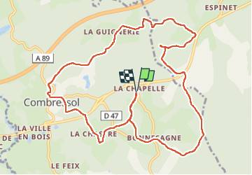

Length
12.9 km

Max alt
719 m

Uphill gradient
294 m
Km-Effort
16.8 km

Min alt
600 m

Downhill gradient
295 m
Boucle
Yes
Creation date :
2025-05-06 12:01:46.204
Updated on :
2025-05-06 15:18:48.481
3h16
Difficulty : Difficult

FREE GPS app for hiking
 SityTrail
IGN / Geographical institutes
SityTrail Plus
The world is yours!
About
Trail Walking of 12.9 km to be discovered at New Aquitaine, Corrèze, Combressol. This trail is proposed by chanac les mines.
Positioning
Country:
France
Region :
New Aquitaine
Department/Province :
Corrèze
Municipality :
Combressol
Location:
Unknown
Start:(Dec)
Start:(UTM)
436030 ; 5036189 (31T) N.
Comments