


Kruth- copines - mercredi-07/05/25

chantalwaltzer
User
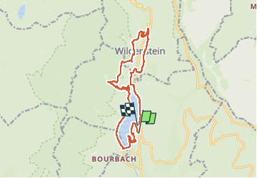

Length
16.4 km

Max alt
884 m

Uphill gradient
711 m
Km-Effort
26 km

Min alt
528 m

Downhill gradient
707 m
Boucle
No
Creation date :
2025-05-07 08:01:48.0
Updated on :
2025-05-07 14:21:16.963
6h18
Difficulty : Very difficult

FREE GPS app for hiking
 SityTrail
IGN / Geographical institutes
SityTrail Plus
The world is yours!
About
Trail Walking of 16.4 km to be discovered at Grand Est, Haut-Rhin, Kruth. This trail is proposed by chantalwaltzer.
Description
marche
Positioning
Country:
France
Region :
Grand Est
Department/Province :
Haut-Rhin
Municipality :
Kruth
Location:
Unknown
Start:(Dec)
Start:(UTM)
347739 ; 5312906 (32T) N.
Comments